
")
July 16 — Florida, USA: The National Hurricane Center (NHC) is closely monitoring a growing cluster of thunderstorms off Florida’s Atlantic coast — a system now officially designated as Invest 93L — for potential tropical development later this week.
🔍 What Is Invest 93L?
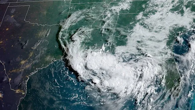
Invest 93L is a weather disturbance identified for special monitoring by the NHC. The label allows the use of high-resolution forecasting models to evaluate its tropical potential. As of Tuesday, the system is becoming better organized, though still disorganized, and is bringing significant rain across Central Florida.
📈 Chance of Development:
- 30% by Wednesday
- 40% through Sunday
The system is forecast to move westward across the Florida Peninsula today (Tuesday), then enter the northeastern Gulf of Mexico by Wednesday. Once over the Gulf, environmental conditions are expected to become more favorable, potentially allowing it to strengthen into a tropical depression or tropical storm.
If it becomes a tropical storm, it will be named Dexter.
🌧️ Rainfall Forecast for Florida:
Regardless of development, heavy rainfall and flash flooding are likely for parts of Florida and the north-central Gulf Coast. The system is expected to act like a “moisture hose”, pumping tropical moisture across the state:
- 1 to 4.5 inches of rain possible in Central Florida by Wednesday
- Rainfall could exceed 3 inches in some areas
- Panhandle and Gulf Coast will see increased rain chances by late week
“Some areas will receive multiple rounds of rain for the next couple of days which can lead to localized flooding,” said the NWS office in Tampa Bay.
🌀 Where Is It Headed?
A high-pressure system drifting westward over the northeastern Gulf will create a pathway for Invest 93L to continue moving west-northwest into the Gulf of Mexico. If conditions hold, it could strengthen into a tropical depression or cyclone as it approaches the northern Gulf Coast later this week.
⚠️ What You Should Know:
- No tropical storm watches or warnings issued yet
- Localized flash flooding is possible through mid to late week
- Stay alert for updated advisories, especially along the Florida Gulf Coast, Alabama, Mississippi, and eastern Texas
The National Weather Service and NHC are urging residents and visitors to monitor the latest forecasts, as conditions could shift quickly.